Terraces of Lungtien (A) and Gautai (B): Active fault scarp and growing
fold in the Longitudinal Valley
Lungtien (stop A) and Gautai (stop B) are located at high large terraces within
the Longitudinal Valley in the Luyeh area (Fig. 1). In effect, large terrestrial
fluvial deposits, which extend from north of Luyeh to the entire Peinanshan
area, appear to be products of the Peinan River and the Luyeh River from Pleistocene
to present-day. Along the Luyeh river banks, at least 3-5 terraces can be observed
at the different heights, indicating a rapid uplift and river incision in the
area. The village of Lungtien is situated on the highest and largest, and presumably
the oldest terrace of the Luyeh River. An N-S trending geomorphic scarp occurs
at the Lungtien terrace.
During the trip, we will observe this scarp at the stop A. The scarp of about
8-12 m high shows the east side going up. GPS data during the last 2-3 years
indicate horizontal shortening occurred across the scarp (Chen et al., 2005).
Together with the leveling data, it indicates that this scarp represents an
active reverse fault scarp. In addition, we can also observe fractures with
compressive features in the retaining walls at the foot of the scarp. This reverse
fault scarp likely represents the surface trace of the Luyeh fault, which has
been previously mentioned, although description is very limited. A few topographic
profiles with detailed measurements across the scarp (Fig. 2) showed a growing
anticlinal fold, which is presumably related to the reverse fault, in the hanging
wall. We interpret this as that the Luyeh fault is probably locked at the shallow
surface level.
Based on the uplifting rate of 7 mm/yr measured from 2002-2003, the 11-m-high
scarp indicates that the Lungtien terrace formed about 1500 years ago, thus
the incision rate of the Luyeh River would be about 4 cm/yr (from a height of
60-70 m between the terrace and the river bed). This rate should be higher,
if considered the co-seismic effect. For example, the 2003 M 6.5 Chengkung earthquake
has significantly accelerated the slip rate of the Luyeh fault (Chen et al.,
2005). This all implies that the Luyeh fault is a rather active fault in the
recent thousands years.
The Luyeh fault extends farther south and it likely affects significantly the
deformation of the Peinanshan massif. The Peinanshan massif is composed of Plio-Pleistocene
shallow marine to fluvial deposits (Chi et al., 1983). This massif is deformed
by two faults on its both sides, the Luyeh fault to the west and the Lichi fault
to the east (Fig. 1). At the top of Gautai (Stop B), we can observe folded strata
of the Peinanshan syncline. In addition, several levels of the terraces of the
Luyeh River show clearly this growing syncline: older the terrace is (i.e.,
higher), more titled.
鹿野高台
鹿野高台飛行場位於龍田臺地上。
由省道9號公路轉入龍田村後,走龍馬路,至永樂路、龍馬路及高台路的路口後,轉入高台路,即可直達高台飛行場。
鹿野溪在此匯流入卑南大溪後,沿都巒山的山腳往南流出。
景色、展望極佳,可一覽近數公里的大致地形狀況,有助於與野外露頭所見相對應。
下述區域地質說明摘自何春蓀(1986)「台灣地質圖概論-台灣地質圖說明書」。經濟部中央地質調查所出版,台北,共164頁。
卑南山礫岩 卑南山礫岩是徐鐵良 (1956) 所訂立的地層名稱,這是一個厚的礫岩層,是海岸山脈中最新的地層單位,主要的出露地點在臺東巿西北方的卑南山。這大部分僅限於海岸山脈南端卑南大溪的下游。卑南山礪岩大多由來自臺東縱谷西邊中央山脈變質岩區的礫石組成,礫石為直徑五到十五公分大小的各種不同變質岩類。本岩層的層理和淘選度都不太好,這一個粗粒碎屑岩是屬於河成的山麓或沖積扇堆積物(pied-mont
deposit) 。 礫岩的生成時代可能在更新世中期或晚期,而其厚度變化很大,在五百到三千公尺之間。卑南山礫岩較利吉混同層更新,局部地方以不整合覆在利吉混同層之上,但是兩者也呈現斷層接觸或犬牙交錯的關係。值得一提的是大南澳片岩的碎片並未在海岸山脈更新世晚期以前的其他岩層中出現,僅見於非海相的卑南山礫岩中,這一個事實對研究臺灣東部板塊衝撞的時間其有重要的意義。大部分的礫岩都受到劇烈的褶皺作用,部分岩層可以傾斜到七十度。
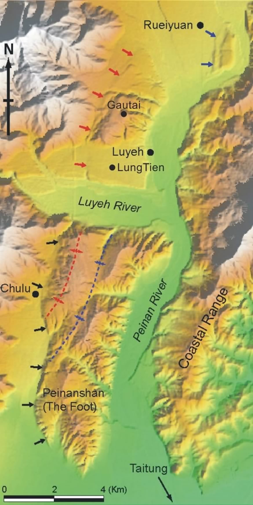 |
Figure 1.
Shading relief of 40-m DTM in the Luyeh and Peinanshan area (from Shyu
et al., 2005). An immense fluvial deposits, including several levels of
river terraces, occupy the Longitudinal Valley, a plate suture between
Eurasia and the Philippine Sea plate. An active fault, the Luyeh fault,
emerges on the western side of this fluvial deposits, showing geomorphic
scarps (arrows) especially in the Luyeh area. |
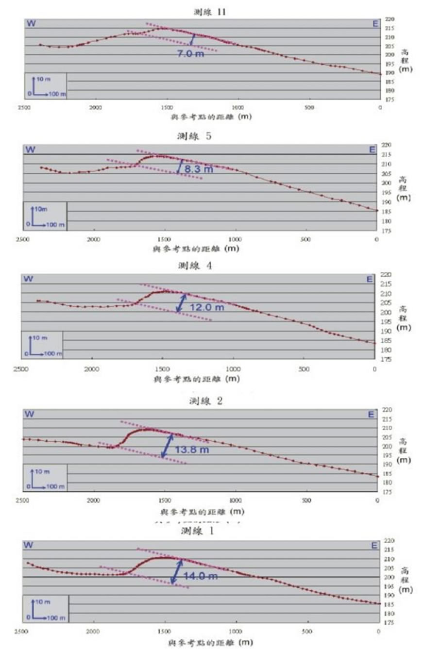 |
Figure 2.
Topographic cross sections across the Luyeh fault (after Chung et al.,
2004). The scarp is estimated to be 8-12 high, which generally increases
towards the south. |
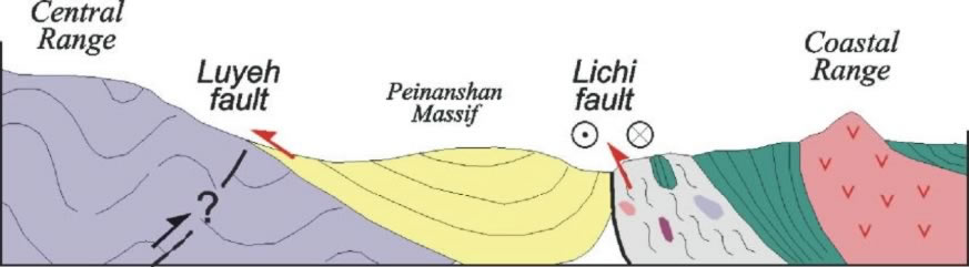 |
Figure 3.
Schematic geological cross section of the Peinanshan massif (modified
after Lee et al., 1998). The Plio-Pleistocene fluvial deposits of the
Peinanshan massif is likely bounded by two faults on its both side and
deformed as a syncline. |
 |
Figure 4.
龍田村道路示意圖。 |
 |
Figure 5.
龍田村及相臨道路示意圖。 |
 |
Figure 6.
跳傘處的180度景觀。
畫面中左側稜線最高點為都巒山。下方的整齊格狀農田,即為龍田村所在。 |
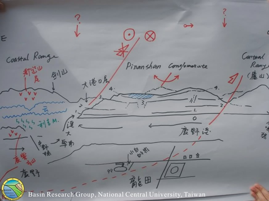 |
Figure 7.
上圖地層及構造示意圖
中央大學地質遙測實驗室張中白老師手繪。 |
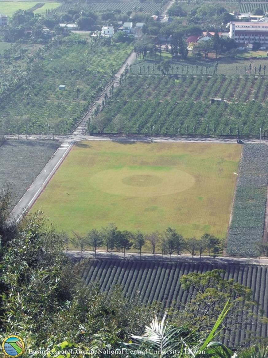 |
Figure 8.
跳傘著陸點的圓形對空標誌。 |
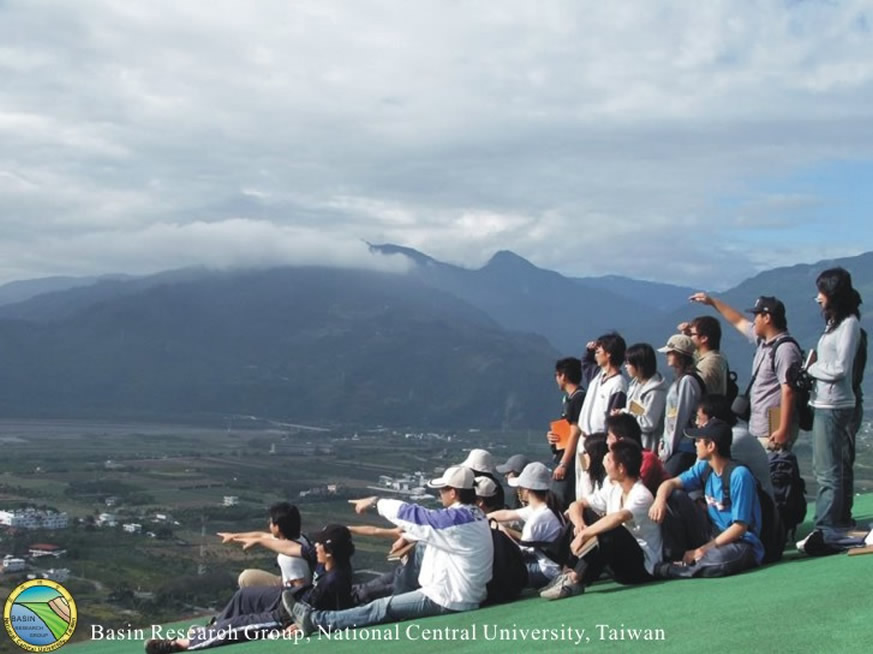 |
Figure 9.
老師講解時,同學專注的神情。 |
 |
Figure 10.
全體參與野外同學合照。 |
 |
Figure 11.
中央大學盆地實驗室林殿順老師與同學合影。 |