Cholan: Active anticline and Cholan Formation
A large earthquake (Mw=7.6) occurred in west-central Taiwan in 1999 with its
epicenter near the small town of Chichi (23.85°N, 120.82°E, Fig.1) and the focal
depth is about 8 km. The Chichi rupture took place mainly along the north-south
stretch of the Chelungpu Fault of about 100 km long and cuts mainly along and
within the Chinshui Shale. At the northern segment of Chichi rupture at Shihkang
township, the rupture turns to an easterly direction and cut stratigraphic upsection
and across the strike of the Cholan Formation.
The Cholan-Neiwan area is located near the north-eastern end of the surface
ruptures of the 1999 earthquake. This stop provides an opportunity for examining
the Chichi ruptures that form in a conjugate pair and help to “push up” the
Tungshih anticline (Figure 2), a decollement fold, as well as examining the
coastal sediments of the Cholan Formation that were accumulated during the later
stage of the foreland basin development.
In the Cholan-Neiwan area, three major surface ruptures were mapped. Two major
NE-SW trending thrusts and one major backthrust, formed in a 2 km wide fault
zone (Fig. 2). The vertical offsets of the individual faults are approximately
1m, 1.5m, and 5-6m for the two major thrusts and the major backthrust (respectively
from west to east). (Excerpt from the Post-Conference Field Trip Guidebook,
“Field Guidebook to the Surface Ruptures of the 1999 Chi-Chi Earthquake” Joint
Geosciences Assembly, 2001)
下述區域地質說明摘自何春蓀(1986)「台灣地質圖概論-台灣地質圖說明書」。經濟部中央地質調查所出版,台北,共164頁。:
卓蘭層 卓蘭層是烏居敬造(1935) 命名的地層,它的標準地點在苗栗縣南部的卓蘭鎮。根據最近的古生物研究,卓蘭層的頂部可能已進入更新世
(見第五表) 。卓蘭層平均厚度為二千公尺 (大約在一千五百到二千五百公尺之間) ,由砂岩、粉砂岩、泥岩、和頁岩的互層組成。由於砂岩和頁岩的抗蝕力不等,所以在互層出露區域常形成單面山
(cuesta) 或豬背嶺 (hogback ridge) 的地形,成為本地層一個重要特徵。在這個巨厚的碎屑沉積岩層中,岩相變化得很快,又缺少指準層,所以很難再把它細分為岩干較明顯的岩段。砂岩常呈淡青灰色或淡灰色,細粒,略含雲母質,層厚為數十公分到二公尺不等,有些較厚的砂岩可以達到五公尺以上的厚度。砂岩的種類有混濁砂岩到亞混濁砂岩等,少數白色正石英砂岩互層也出現在本層內。頁岩和泥岩呈現青灰色或暗灰色,一般層厚在二十至五十公分間,部分地方也出現有較厚的頁岩層。
卓蘭層內具有交錯層和波痕,顯示本地層大部是淺水相的沉積物。本層內的砂岩質較鬆軟,只有受到石灰質浸染的部分比較堅硬。本層的上部有淡灰色、塊狀細粒的泥質砂岩,其中含有炭化漂木的碎塊、炭質顆粒、和粗粒的碎岩屑。卓蘭層的上部夾有凸鏡體或薄層礫岩,向上礫岩增加,就漸變為頭嵙山層,兩地層的中間並沒有明顯的沉積間斷和分界線。任何一個最早出現在卓蘭層最上部厚而明顯的礫岩層在地層學上的意羲是頗為重要的,在野外製圖時,通常都用這一個礫岩層做為卓蘭層頂部或是頭嵙山層底部的指準層。卓蘭層富含化石群,包括有海膽、蟹、貝類、和有孔蟲等。此外在砂岩中還可以發現崩移
(slumping) 構造,荷重鑄型,和球枕狀構造 ( ball and Pillowstructure) 等。
在臺北和嘉羲之間,卓蘭層內砂岩所占的比例為百分之四十到六十。從嘉義向南,卓蘭層內砂岩所占的比例就逐漸減低,粒度也跟著變細,同時暗灰色頁岩、泥岩、和粉砂岩則漸漸成為相當卓蘭層地層中的主要成分,而且地層的厚度也增加很多。在臺南和高雄之間,和卓蘭層相當的地層中砂岩所占的比例只有百分十以下,整個地層都變成一個巨厚的泥岩系,所謂狹義的古亭坑層即指此而言。
在嘉義地區,中國石油公司的地質人員已把上新世地層劃分為若干岩石地層單位 (Stach,1957),其中一部已在討論桂竹林層時說明過,另外和錦水頁岩及卓蘭層相當的地層自下而上
有澐水溪層及六重溪層兩個地層 :
澐水溪 (四百五十公尺) 頁岩和砂質頁岩夾泥質砂岩的互層和石灰岩礁凸鏡體。
六重溪層 (七百六十公尺) 砂質頁岩和泥質砂岩。
在臺南縣和高雄縣一帶,和錦水頁岩與卓蘭層相當的地層有竹頭崎層和北寮頁岩,都是何春蓀 (1956) 調查臺南縣竹頭崎油田時所提出來的地層名稱。竹頭崎層中含有三至五層凸鏡狀的砂岩厚層,每一層厚約十到三十公尺以上,各砂岩層間為厚層深灰色頁岩或砂岩與頁岩的互層所分開。最下的砂岩層可以代表本層的底部,蓋在茅埔頁岩的上面。砂岩呈淺灰色,泥質,常常局部尖滅,甚或消失不見。竹頭崎層的厚度變化不一,可以從五百到七百公尺。北寮頁岩整合於竹頭崎層的上面,由青灰色至灰黑色頁岩組成,一部呈泥岩狀,有時微呈帶狀結構,偶夾薄層或凸鏡狀的細砂岩和頁岩與細砂岩所成的薄互層。北寮頁岩非常厚,估計可達一千二百公尺。
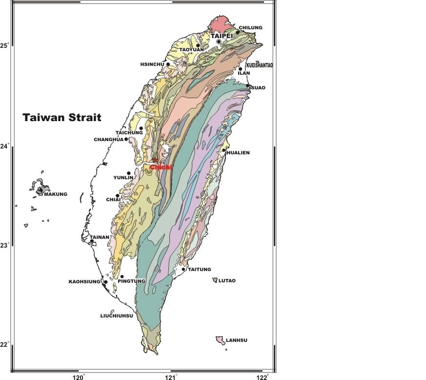 |
Figure 1. |
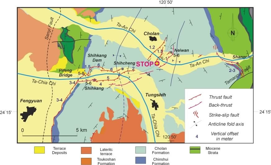 |
Figure 2.
Map of the northern surface ruptures of the 1999 Chi-Chi earthquake
in the Shihkang-Shangchi fault zone (after Lee et al., 2002; see Fig.
3 for map location). The vertical displacements observed on the fault
scarps are shown as numbers on the map. Note that the earthquake surface
faults as well as the local young folding structures (trending E-W to
NE-SW) within the Cholan Formation have obliquely cut across the regional
old anticlinal and synclinal fold structures (trending N-S). Field stops
are shown as red circles with stars. |
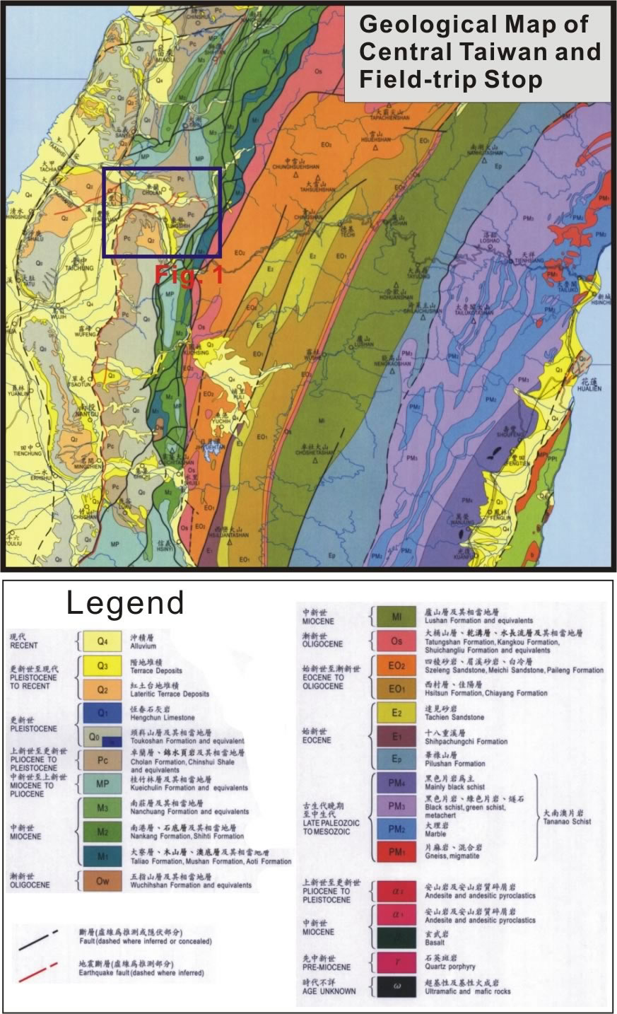 |
Figure 3. |
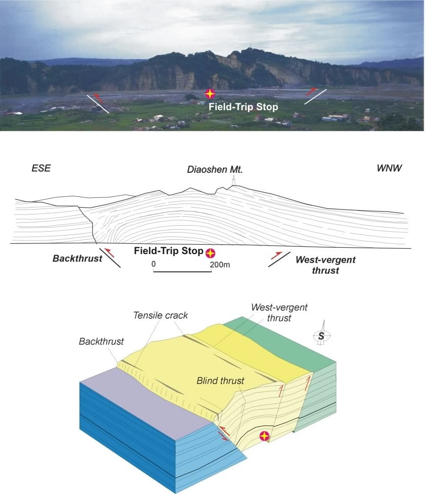 |
Figure 4.
Field-Trip Stop. Pop-up structure with thrust-and-backthrust system
situated on a pre-existing anticlinal fold, the Tungshih anticline, in
the Diaoshenshan area near Neiwan (after Lee et al., 2002). Field stop
is shown as red circle. The major thrust of the 1999 earthquake occurred
along the backlimb (i.e., left of the above figures) of the Tungshih anticline.
The gentle open fold of the Tungshih anticline probably is part of contribution
of several recent earthquakes in a time span of tens of thousand years. |