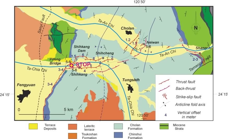
Figure 1.
Map of the Shihkang Dam and Beifeng Bridge.
Shihkang Dam and Beifeng Bridge: Sites of great damage caused by the 1999 Chichi Earthquake
|
Figure 1. Map of the Shihkang Dam and Beifeng Bridge. |
Shihkang Dam:
In Shihkang, a system of multiple thrusts and a major backthrust slipped during
the earthquake. First, to the north of Shihkang in the Tachia River, two thrust
faults ruptured across the northern part of the Shihkang Dam. A major thrust,
linked to the main thrust at the Pifeng Bridge to the west, exhibited a large
vertical displacement of 8-10 m (according to the offset of the dam crest).
The Shihkang Dam is located at the bottom of a triangular zone, of which two
edges were formed by a major thrust and a backthrust (Lee et al., 2002). The
thrust and the backthrust extend to the south of the Pifeng Bridge area and
gradually increase in displacement on both sides of the Shihkang Dam. At least
two major thrusts have been found to be closely associated with the destruction
of the dam (Chen et al., 2000). The N-S trending main body of the dam was deformed
to a gentle anticline. This N-S to NNW-SSE compression was also reflected by
a series of pressure ridges at the foot of the dam. (Excerpt from the Post-Conference
Field Trip Guidebook, “Field Guidebook to the Surface Ruptures of the 1999 Chi-Chi
Earthquake” Joint Geosciences Assembly, 2001)
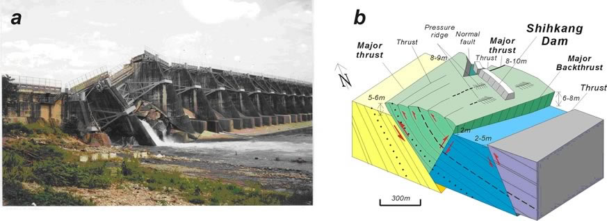 |
Figure 2. Shihkang Dam. Complex deformation and fault system in the Shihkang Dam area (after Lee et al., 2002). See Fig. 9 for location. (a) Photograph of the Shihkang Dam showing the breaks of the dam body with a vertical offset of 8-10 meters. (b) A 3-D block-diagram of the deformation in the Shihkang Dam area. The Shihkang Dam is located on the pop-up fold lifted by thrust and backthrust. At least two thrusts situated on the northern end of the dam have broken the dam. The rest of the dam body has been folded and several different scales of pressure ridges can be observed along the foot of the dam. |
Pifeng Bridge:
On the western side of the northern segment near the Pifeng Bridge (Fig. 3),
the surface rupture extended across the active channel of the Tachia River and
formed a spectacular waterfall of 5-6 m in height (Lee et al., 2002). At least
three other 20-40 cm high minor thrusts were also located on the hanging wall
of the main surface rupture (i.e., the waterfall, Fig. 13b). These faults cut
50°-60°-dipping strata of the Chinshui Shale parallel to the bedding or at a
small angle of 10-20 degrees.
Slickenside lineations on the fault planes were observed on the exposed ruptures
in the fine-grained sandstone bedrock of the Chinshui Shale. The fault striations
revealed dip-slip movements with minor lateral slip for both the main fault
and the minor faults. Stress tensor inversions indicate NW-SE directed compression
on a NE-SW trending reverse fault dipping to the southeast. The stress tensor
is generally consistent with the focal mechanism of the main shock of the earthquake
(Chung and Shin, 1999; Ma et al., 2000; Kao and Chen, 2000). Note that it is
in good agreement with the focal solution of the northern sub-event of the main
shock (Kao and Chen, 2000). However, a 15-20 degrees clockwise change in the
trend of the maximum principal compressive stress direction occurs between the
earthquake focus located 50 km to the south and at the Pifeng Bridge site. Slip
on the main thrust can be illustrated by a 3-D displacement vector with a vertical
offset of 3.5 m, a horizontal shortening of 2.0 m, and a small amount of left-lateral
strike-slip of 0.6 m. The main fault in the Pifeng area strikes N40°E and dips
to the east at about 60°; the hanging wall block of the fault moved in the direction
of N320°E. (Excerpt from the Post-Conference Field Trip Guidebook, “Field Guidebook
to the Surface Ruptures of the 1999 Chi-Chi Earthquake” Joint Geosciences Assembly,
2001).
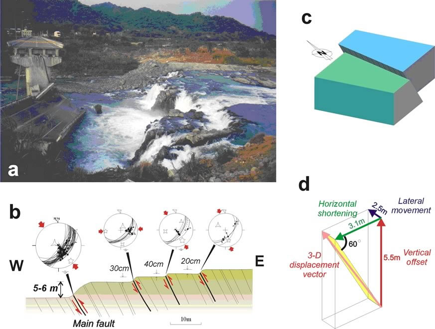 |
Figure 3. Pifeng Bridge. (after Lee et al., 2002). (a) The Chichi rupture cut across the Tachia River bed and created a 5-6 m high waterfall while damaging the Pifeng Bridge during the Chichi earthquake. (b) Kinematics analysis and reconstruction of the movement of the fault in the Pifeng bridge area along the Tachi River, near Shihkang. A multi-fault system has been found on the riverbeds and clear striations have been observed on the fault planes and have been measured in order for the kinematics analysis. (c, d) 3-D reconstruction of the displacement vectors shows that the main fault can be represented by a west-vergent reverse fault (strikes N30°E, dips 60° to SE) with a minor left-lateral strike-slip component. |
下述區域地質說明摘自何春蓀(1986)「台灣地質圖概論-台灣地質圖說明書」。經濟部中央地質調查所出版,台北,共164頁。:
錦水頁岩 錦水頁岩最早為安藤昌三郎 (1930) 在苗栗油田地質研究報告中提出來的,它的標準地點錦水是錦水天然氣田中央的一個小村莊,由於它的特殊岩性和化石群,這一個頁岩單位可以作為臺灣西部地層對比上的重要指準層,本層向上向下分別和卓蘭層及桂竹林層整合接觸。頁岩呈深灰色,具有發育良好的球狀剝離構造,通常夾有暗灰色凸鏡狀砂岩層以及粉砂岩和泥岩的薄層。有些地方頁岩的淘選度很差,並且富含泥灰岩結核。在錦水盆地的中央,錦水頁岩的最大厚度約在四百公尺左佑,但是地層向東和向西都薄至一百公尺或更薄。在臺灣中部,錦水頁岩的厚度約在八十至一百公尺之間。錦水頁岩是在淺海或較其略深的環境中沉積而成,富含各種海相生物,本地層中所含的化石包括有蟹、腹足類、斧足類、有孔蟲煩、和珊瑚等。
卓蘭層 卓蘭層是烏居敬造(1935) 命名的地層,它的標準地點在苗栗縣南部的卓蘭鎮。根據最近的古生物研究,卓蘭層的頂部可能已進入更新世 (見第五表) 。卓蘭層平均厚度為二千公尺 (大約在一千五百到二千五百公尺之間) ,由砂岩、粉砂岩、泥岩、和頁岩的互層組成。由於砂岩和頁岩的抗蝕力不等,所以在互層出露區域常形成單面山 (cuesta) 或豬背嶺 (hogback ridge) 的地形,成為本地層一個重要特徵。在這個巨厚的碎屑沉積岩層中,岩相變化得很快,又缺少指準層,所以很難再把它細分為岩干較明顯的岩段。砂岩常呈淡青灰色或淡灰色,細粒,略含雲母質,層厚為數十公分到二公尺不等,有些較厚的砂岩可以達到五公尺以上的厚度。砂岩的種類有混濁砂岩到亞混濁砂岩等,少數白色正石英砂岩互層也出現在本層內。頁岩和泥岩呈現青灰色或暗灰色,一般層厚在二十至五十公分間,部分地方也出現有較厚的頁岩層。
卓蘭層內具有交錯層和波痕,顯示本地層大部是淺水相的沉積物。本層內的砂岩質較鬆軟,只有受到石灰質浸染的部分比較堅硬。本層的上部有淡灰色、塊狀細粒的泥質砂岩,其中含有炭化漂木的碎塊、炭質顆粒、和粗粒的碎岩屑。卓蘭層的上部夾有凸鏡體或薄層礫岩,向上礫岩增加,就漸變為頭嵙山層,兩地層的中間並沒有明顯的沉積間斷和分界線。任何一個最早出現在卓蘭層最上部厚而明顯的礫岩層在地層學上的意羲是頗為重要的,在野外製圖時,通常都用這一個礫岩層做為卓蘭層頂部或是頭嵙山層底部的指準層。卓蘭層富含化石群,包括有海膽、蟹、貝類、和有孔蟲等。此外在砂岩中還可以發現崩移 (slumping) 構造,荷重鑄型,和球枕狀構造 ( ball and Pillowstructure) 等。
在臺北和嘉羲之間,卓蘭層內砂岩所占的比例為百分之四十到六十。從嘉義向南,卓蘭層內砂岩所占的比例就逐漸減低,粒度也跟著變細,同時暗灰色頁岩、泥岩、和粉砂岩則漸漸成為相當卓蘭層地層中的主要成分,而且地層的厚度也增加很多。在臺南和高雄之間,和卓蘭層相當的地層中砂岩所占的比例只有百分十以下,整個地層都變成一個巨厚的泥岩系,所謂狹義的古亭坑層即指此而言。
在嘉義地區,中國石油公司的地質人員已把上新世地層劃分為若干岩石地層單位 (Stach,1957),其中一部已在討論桂竹林層時說明過,另外和錦水頁岩及卓蘭層相當的地層自下而上 有澐水溪層及六重溪層兩個地層 :
澐水溪 (四百五十公尺) 頁岩和砂質頁岩夾泥質砂岩的互層和石灰岩礁凸鏡體。
六重溪層 (七百六十公尺) 砂質頁岩和泥質砂岩。
在臺南縣和高雄縣一帶,和錦水頁岩與卓蘭層相當的地層有竹頭崎層和北寮頁岩,都是何春蓀 (1956) 調查臺南縣竹頭崎油田時所提出來的地層名稱。竹頭崎層中含有三至五層凸鏡狀的砂岩厚層,每一層厚約十到三十公尺以上,各砂岩層間為厚層深灰色頁岩或砂岩與頁岩的互層所分開。最下的砂岩層可以代表本層的底部,蓋在茅埔頁岩的上面。砂岩呈淺灰色,泥質,常常局部尖滅,甚或消失不見。竹頭崎層的厚度變化不一,可以從五百到七百公尺。北寮頁岩整合於竹頭崎層的上面,由青灰色至灰黑色頁岩組成,一部呈泥岩狀,有時微呈帶狀結構,偶夾薄層或凸鏡狀的細砂岩和頁岩與細砂岩所成的薄互層。北寮頁岩非常厚,估計可達一千二百公尺。