921 Earthquake Museum of Taiwan (Formerly of Kuangfu Junior High School)
Near the central portion of the 100-km stretch Chichi rupture, the fault segment
cuts across the sport stadium of the Kuangfu Junior High School at Wufeng and
creates a 2-3 m fault scarp (Angelier et al., 2003, Fig. 1, see Fig. 2 for stop
location). The site has now become the earthquake museum to commemorate the
loss caused by the Chichi earthquake and to witness the surface rupture brought
about by the earthquake.
The segment of the Chelungpu fault scarp across the Kuangfu stadium is about
100 m long and trends NW-SE (Fig. 1). To the NW, the scarp cuts across the western
half-ellipse of the stadium. This sub-segment is 12 m long and strikes N125-130°E,
almost perpendicular to the run tracks. Because of their elliptic shape, the
tracks trend approximately N40°E on the hangingwall and N20° on the footwall.
To the SE, the scarp cuts across the southern straight line of the stadium.
This sub-segment is 18 m long and strikes N125-135°E, oblique at an angle of
about 45° to the run tracks. The tracks are rectilinear and trend N86°E on both
sides of the rupture zone. Between the two sub-segments, the scarp runs across
the central pool of the stadium; it is approximately 70 m long and strikes N152°E
on average. The local fault strikes vary because the shape of the scarp was
influenced by the mechanical response of the surface layers, including the stadium
track cover. These local strikes do not reflect the fault geometry at depth,
even at the 100 m scale considered. The average trend of the whole fault segment
of the Kuangfu stadium, N141°E, is considered as the local strike of the Chelungpu
fault. (Excerpt from the Post-Conference Field Trip Guidebook, “Field Guidebook
to the Surface Ruptures of the 1999 Chi-Chi Earthquake” Joint Geosciences Assembly,
2001)
下述區域地質說明摘自何春蓀(1986)「台灣地質圖概論-台灣地質圖說明書」。經濟部中央地質調查所出版,台北,共164頁。:
錦水頁岩 錦水頁岩最早為安藤昌三郎 (1930) 在苗栗油田地質研究報告中提出來的,它的標準地點錦水是錦水天然氣田中央的一個小村莊,由於它的特殊岩性和化石群,這一個頁岩單位可以作為臺灣西部地層對比上的重要指準層,本層向上向下分別和卓蘭層及桂竹林層整合接觸。頁岩呈深灰色,具有發育良好的球狀剝離構造,通常夾有暗灰色凸鏡狀砂岩層以及粉砂岩和泥岩的薄層。有些地方頁岩的淘選度很差,並且富含泥灰岩結核。在錦水盆地的中央,錦水頁岩的最大厚度約在四百公尺左佑,但是地層向東和向西都薄至一百公尺或更薄。在臺灣中部,錦水頁岩的厚度約在八十至一百公尺之間。錦水頁岩是在淺海或較其略深的環境中沉積而成,富含各種海相生物,本地層中所含的化石包括有蟹、腹足類、斧足類、有孔蟲煩、和珊瑚等。
卓蘭層 卓蘭層是烏居敬造(1935) 命名的地層,它的標準地點在苗栗縣南部的卓蘭鎮。根據最近的古生物研究,卓蘭層的頂部可能已進入更新世 (見第五表) 。卓蘭層平均厚度為二千公尺 (大約在一千五百到二千五百公尺之間) ,由砂岩、粉砂岩、泥岩、和頁岩的互層組成。由於砂岩和頁岩的抗蝕力不等,所以在互層出露區域常形成單面山 (cuesta) 或豬背嶺 (hogback ridge) 的地形,成為本地層一個重要特徵。在這個巨厚的碎屑沉積岩層中,岩相變化得很快,又缺少指準層,所以很難再把它細分為岩干較明顯的岩段。砂岩常呈淡青灰色或淡灰色,細粒,略含雲母質,層厚為數十公分到二公尺不等,有些較厚的砂岩可以達到五公尺以上的厚度。砂岩的種類有混濁砂岩到亞混濁砂岩等,少數白色正石英砂岩互層也出現在本層內。頁岩和泥岩呈現青灰色或暗灰色,一般層厚在二十至五十公分間,部分地方也出現有較厚的頁岩層。
卓蘭層內具有交錯層和波痕,顯示本地層大部是淺水相的沉積物。本層內的砂岩質較鬆軟,只有受到石灰質浸染的部分比較堅硬。本層的上部有淡灰色、塊狀細粒的泥質砂岩,其中含有炭化漂木的碎塊、炭質顆粒、和粗粒的碎岩屑。卓蘭層的上部夾有凸鏡體或薄層礫岩,向上礫岩增加,就漸變為頭嵙山層,兩地層的中間並沒有明顯的沉積間斷和分界線。任何一個最早出現在卓蘭層最上部厚而明顯的礫岩層在地層學上的意羲是頗為重要的,在野外製圖時,通常都用這一個礫岩層做為卓蘭層頂部或是頭嵙山層底部的指準層。卓蘭層富含化石群,包括有海膽、蟹、貝類、和有孔蟲等。此外在砂岩中還可以發現崩移 (slumping) 構造,荷重鑄型,和球枕狀構造 ( ball and Pillowstructure) 等。
在臺北和嘉羲之間,卓蘭層內砂岩所占的比例為百分之四十到六十。從嘉義向南,卓蘭層內砂岩所占的比例就逐漸減低,粒度也跟著變細,同時暗灰色頁岩、泥岩、和粉砂岩則漸漸成為相當卓蘭層地層中的主要成分,而且地層的厚度也增加很多。在臺南和高雄之間,和卓蘭層相當的地層中砂岩所占的比例只有百分十以下,整個地層都變成一個巨厚的泥岩系,所謂狹義的古亭坑層即指此而言。
在嘉義地區,中國石油公司的地質人員已把上新世地層劃分為若干岩石地層單位 (Stach,1957),其中一部已在討論桂竹林層時說明過,另外和錦水頁岩及卓蘭層相當的地層自下而上 有澐水溪層及六重溪層兩個地層 :
澐水溪 (四百五十公尺) 頁岩和砂質頁岩夾泥質砂岩的互層和石灰岩礁凸鏡體。
六重溪層 (七百六十公尺) 砂質頁岩和泥質砂岩。
在臺南縣和高雄縣一帶,和錦水頁岩與卓蘭層相當的地層有竹頭崎層和北寮頁岩,都是何春蓀 (1956) 調查臺南縣竹頭崎油田時所提出來的地層名稱。竹頭崎層中含有三至五層凸鏡狀的砂岩厚層,每一層厚約十到三十公尺以上,各砂岩層間為厚層深灰色頁岩或砂岩與頁岩的互層所分開。最下的砂岩層可以代表本層的底部,蓋在茅埔頁岩的上面。砂岩呈淺灰色,泥質,常常局部尖滅,甚或消失不見。竹頭崎層的厚度變化不一,可以從五百到七百公尺。北寮頁岩整合於竹頭崎層的上面,由青灰色至灰黑色頁岩組成,一部呈泥岩狀,有時微呈帶狀結構,偶夾薄層或凸鏡狀的細砂岩和頁岩與細砂岩所成的薄互層。北寮頁岩非常厚,估計可達一千二百公尺。
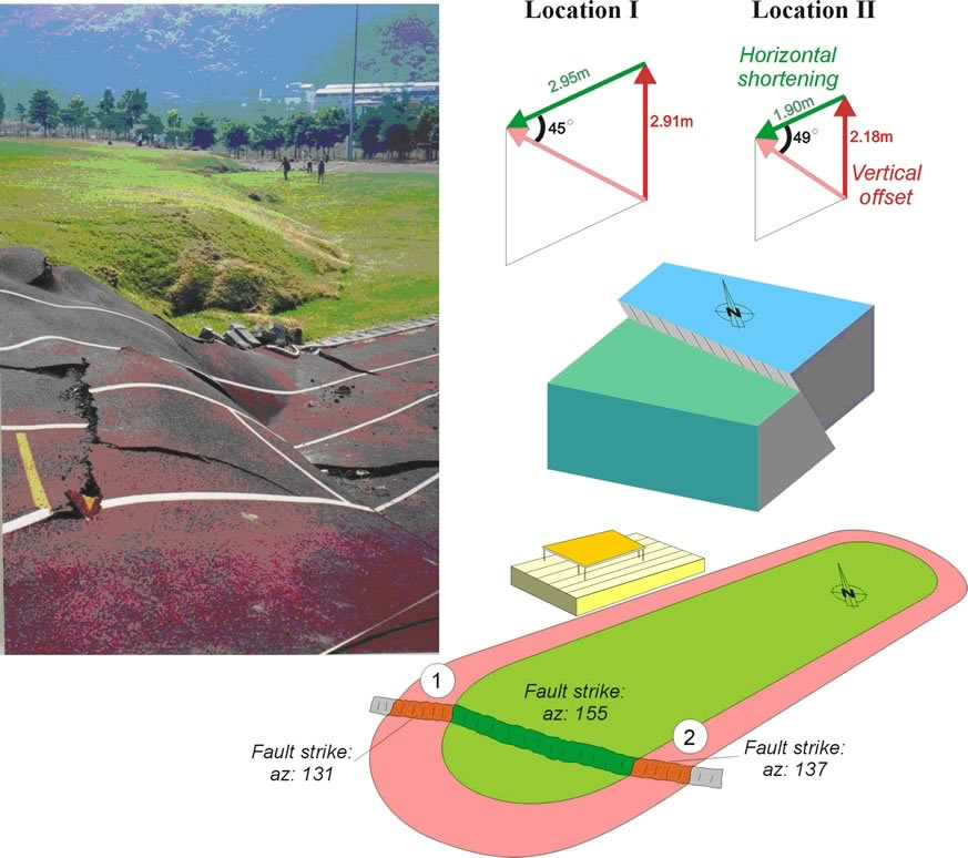 |
Figure 1.
Kinematics analysis and reconstruction of the movement of the fault
in the Kuangfu school, near Wufeng (after Angelier et al., 2003). The
earthquake fault formed a 2-m high thrust scarp and cut through the sport
stadium. The lines on the running tracks allow measuring the displacements
of the fault in 3 dimensions. Note that the strike of the surface fault
changed because of the different mechanical properties of surface materials.
The reconstructed fault geometry shows a reverse fault with a fault plane
dipping 45°-50° to the east. |
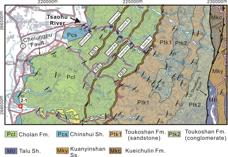 |
Fig. 2
stop location |
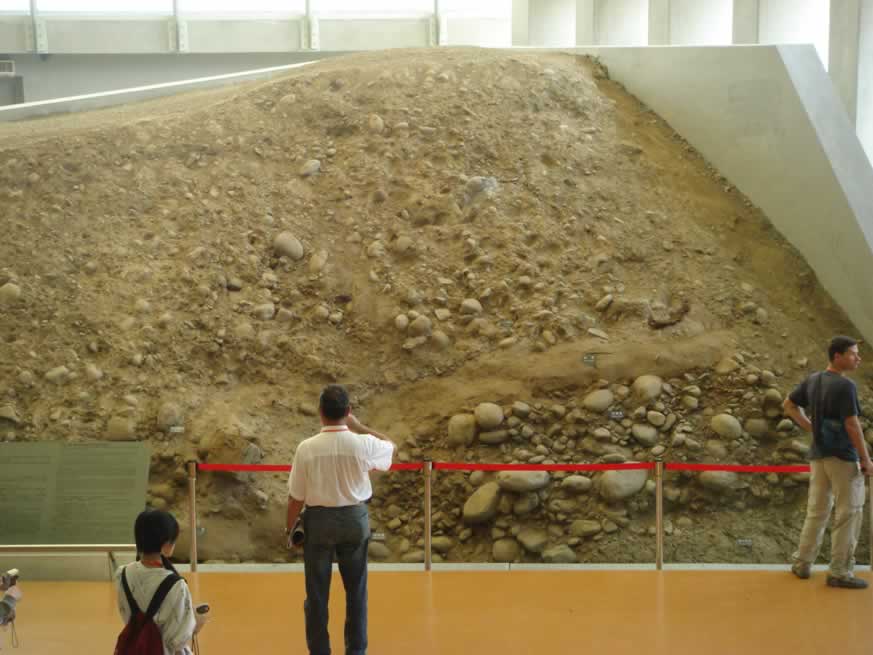 |
Fig. 3
地震博物館內的現地露頭保存 。可見岩層左右明顯的不連續,為受地震錯動的結果。 |