| Geology, bathymetry and active strcutres of Taiwan |
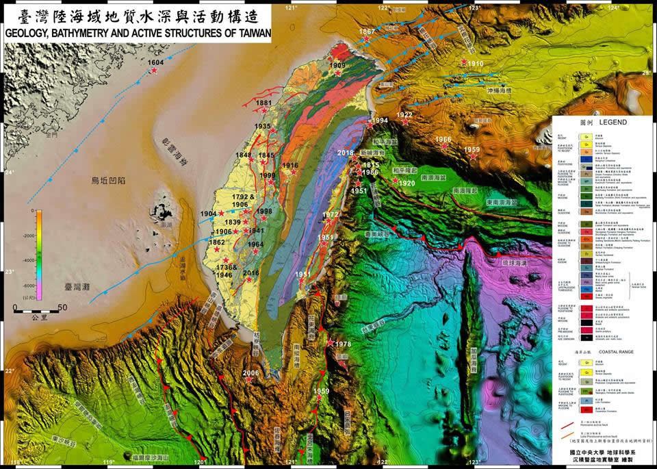 |
High-resolution map downoad (22 MB)
Taiwan historical earthquakes (12 MB) |
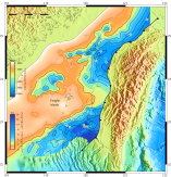
| Depth to the top of Mesozoic basement in the Taiwan Strait and coastal plain |
|
A4-sized map (2 Mb), A0-sized map (pdf, 5 Mb)
Gridded data (rift_unc_depth_1m_km.grd, readable by GMT)
Clip path (thrust-500_0.xy), Readme.txt
Source: from Figure 2 Lin, A. T., A. B. Watts and S. P. Hesselbo (2003) Cenozoic stratigraphy and subsidence history of the South China Sea margin in the Taiwan region. Basin Research, 15 (4), 453-478. |
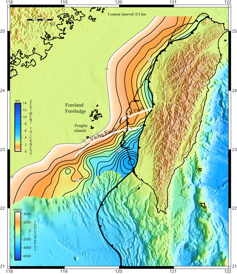
| Depth to the base of the Taiwan foreland basin |
|
A4-sized map (1.6 Mb), A0-sized map (pdf, 5 Mb), Deformation front
Source: from Figure 4 in Lin, A. T. and A. B. Watts (2002) Origin of the WestTaiwanBasin by orogenic loading and flexure of a rifted continental margin. Journal of Geophysical Research, 107(B9), 2185, doi:10.1029/2001JB000669. |
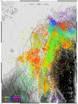
| Earthquake hypocentral locations in the Taiwan region |
|
A2-sized map (pdf, 10 Mb)
Source: from Figure 11 in Lin, A. T. and A. B. Watts (2002) Origin of the WestTaiwanBasin by orogenic loading and flexure of a rifted continental margin. Journal of Geophysical Research, 107(B9), 2185, doi:10.1029/2001JB000669. |
| Central Geological Survey |
| Geo2010 (WebЁBsoftware) |
Borehole data bank for engineering geological investigations in Taiwan |
| Geological maps and literatures |
Databases for (1) geological maps, (2) literature published in Taiwan, (3) engineering boreholes |
| Active Faults |
Active faults in Taiwan (Central Geological Survey) |
| Cores and reports |
Cores and reports for hydrogeological study archived in Central Geological Survey |
| Taiwan Environmental Geology (Geological hazards) |
ЉYІaРєЙвІaНшИъЎЦЎw |
| National Taiwan University |
| Rock Database |
Taiwan rock samples archived in NTU Geosciences |
| National Museum of Natural Science |
| Rocks, minerals, fossils |
Taiwan rocks, minerals, fossils archived in NMNS. |
| Taiwan Ocean Data NET Work |
| Bathymetry/topography |
Bathymetry data around Taiwan |
| Bathymetry around the South China Sea |
Hydrographic Data Bank System of South China Sea |
| Gravity/magnetics |
Marine gravity and aeromagnetic data |
| Heatflows |
Marine heatflow measurements |
| Reflection seismic profiles |
Marine reflection seismic profiles |
| Chirp Sonar |
Chirp sonar data around Taiwan |
| Marine sediment sampling sites |
Box, dredge, gravity, piston, grab cores around Taiwan |
| Core repository and laboratory |
Marine cores and data |
| Hydrographic Data (CTD data) |
Temperature, Salinity, and Density variations with increasing depth around Taiwan |
| Current Velocity Data (ADCP data) |
Flow velocity around Taiwan |
| Taiwan Strait Nowcast System (TSNOW) |
Predicting current velocity, sea level in the Taiwan Strait |
| Institute of Applied Geology, NCU |
| Taiwan Earthquake Catalog |
ЅxЦWІaО_ИъЎЦЌdИп |
| Taiwan GIS data |
ЅxЦWІaАЯІaВzИъАTЌdИпЈtВЮ |
| Active Faults |
ЅxЦWЌЁТ_МhЌdИпЈtВЮ |
| Geological Maps |
ІaНшЙЯДTЌdИп |
| Topographic maps |
ІaЇЮЙЯЌdИп |
| Water Resources Agency |
| Hydrological data |
Annual data reports since 1936 |
| Geographic Information Storage Center |
ЄєЇQИpІaВzИъАTмРxЄЄЄп |
| Satellite Survey Center(Dept. of Land Administration, M.O.I.) |
| Others |
| Taiwan Gazetteer |
ІaІWЄхФmЗjЏС |
| 1/25,000 topographic maps |
Generate 1/25,000-scale topographic maps and output as png files |
| Taiwan Triangulation Point's Coordinates |
| Taiwan 1/50,000 maps index |
| Aerial Survey Office, Forestry Bureau |
ЙAЊLЏшЊХДњЖqЉв |
| Digital Map Taiwan |
ЅxЦWЙqЄlІaЙЯ |
| Ancient map of Taiwan |
ЅxЦWЅjІaЙЯ |
| Comparison of old and new maps in Taiwan |
ЅxЦWЗsТТІaЙЯЙяЄё |
| Data_giletycz_etal_2020 |
Data used in Giletycz et al. 2020 |


